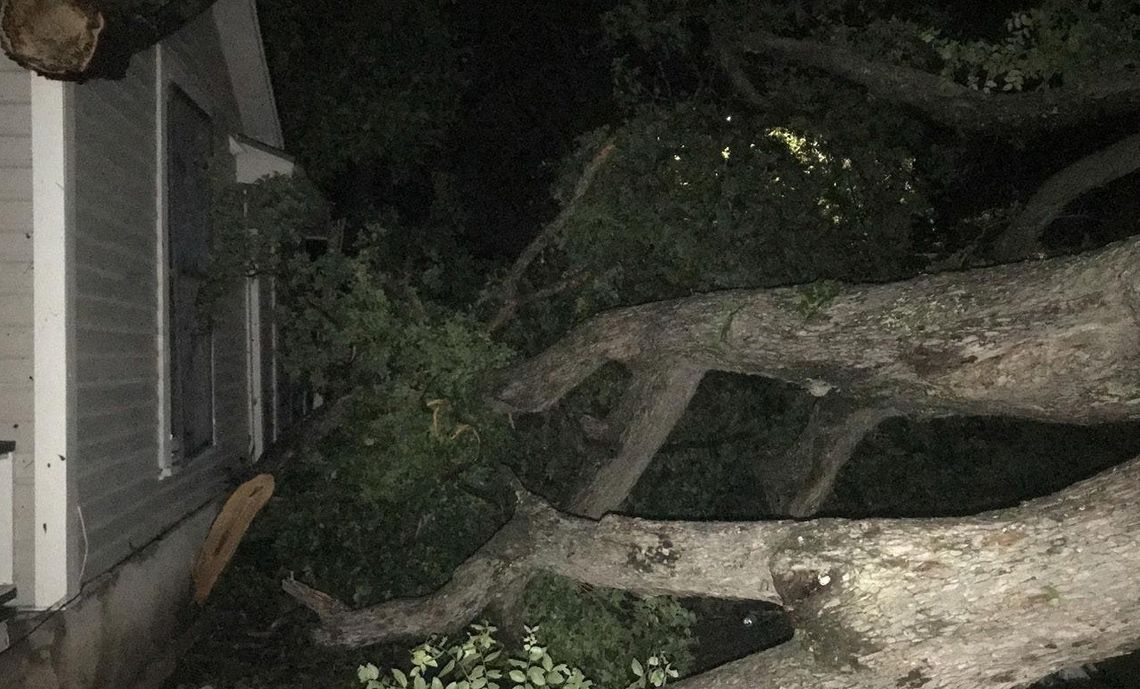
It was a typical hot and humid afternoon with clear skies at 7:35 p.m. Thursday when phones across town began buzzing with an emergency alert from the National Weather Service that stated “Severe Thunderstorm Warning in effect for this area until 8:30 .m. for destructive aseball size hail. Take shelter in a sturdy building, away from windows. People and animals outdoors will be severely injured.” Within ten minutes, the violent storm tore through the city. To add to the panic, a Tornado Warning was issued at 8:22 p.m., and residents across town - at least those willing to heed the warning — hunkered down in the innermost room of their homes and awaited an uncertain future.
Nick Hampshire, National Weather Service Austin/San Antonio meteorologist, said as of right now, it appears that there was just widespread straight line winds and two to two and half inch hail spread across Hays County with pictures showing some pieces as large as four inches.
“The storm had a brief signature there where [there] may have been rotating, but the straight line winds overtook that signature really quickly,” Hampshire said.
‘ So as of now, it looks like a tornado wasn't able to form because of it.”
Hays County Emergency Management Director Ruben Becerra said Buda and Kyle had very minimal damage that consisted of fallen tree branches.
Additionally, Wimberley had significant hail damage, down lines and limbs as well as other areas in northwest Hays County.
“[The place] that captured the most impact was in the city of San Marcos,” Becerra said. “This is where we lost roofs, chimneys, trees and everything in between.”
Khameyah Taylor, city of San Marcos public safety communications specialist, said that San Marcos utility crews were working throughout the night to address damage caused by the storm.
“Reports indicate significant damage from wind and hail, including downed trees, power lines, and traffic signal disruptions,” Taylor said.
Orrin and Deborah McCray, San Marcos residents, were at Sewell Park when they received the alert. The graduation ceremony was also occurring, and they were directed to drive over the bridge on Aquarena Springs Drive. They took the turnaround and were stuck behind a train along with all of the cars from the graduation ceremony, and then, like anyone form San Marcos would expect, the train put on its brakes. He said people were crossing between the train cars to get to their vehicles on the other side of the tracks. They saw small children going underneath the train, and a person passed a small baby to another individual between the train cars.
“And just like that, it started to happen. People started scrambling, driving everywhere, and we happened to drive over the median and just [tried to] get the truck, hopefully, underneath the bridge, which is right underneath the overpass of where the stadium is now. We parked underneath there, and several other cars were crammed underneath there just to get out of the hail,” Orrin McCray said. “It was so strong. It moved the vehicle side to side. … It rocked all those vehicles quite a bit for about a good two minutes. We were under there for about 10 [minutes], and by that time, the storm had cleared.”
There are anecdotal reports of more severe damage near Redwood. Andrew Munk, chief of the York Creek Volunteer Fire Department that covers Staples, Redwood and Zorn, said there were several power lines down, uprooted trees and trees on top of houses.
“We had some partial structural collapses [and] roofs missing. It was pretty much the usual things that happen with high wind events,” Munk said. “We had quite a few trees down across roads and [were] blocking roads completely.“ Munk said quite a few homes have somewhat superficial damage.
“The tin is missing or siding is missing or [there is] a porch that may be gone. It isn't a full structural collapse,” Munk said. “We did have one full structure collapse in the Redwood area.”
Munk said there was damage all the way through Redwood and Staples as well as toward Fentress — his entire service area.
“It is hard to tell what it actually was if it was down burst straight line winds or something else,” Munk said.
Guadalupe County officials, which cover the area just east of San Marcos, said the northern part of Guadalupe County suffered widespread damages due to the storm. There were damage reports of heavy rains, high winds, hail, tornado damage, damaged trees and power outages. Emergency crews are in the area continuing to assess damage and clean up debris, and the electric company is working to restore power. Patrick Pinder, Guadalupe County emergency management coordinator and fire marshal, said there is widespread damage to homes, partial collapse of some structures and power outages due to the strong winds and damage caused by large trees in Guadalupe County. He added that first responders and emergency crews worked throughout the night searching homes and using equipment to safely remove large debris from the roadway to prepare for morning traffic.
According to the city of San Marcos, SMTX Utilities were actively addressing ongoing outages resulting from the storm as of 10 a.m. Friday.
The city of San Marcos scheduled a brush drop for May 11. City Staff is currently evaluating conditions and will provide an update on additional brush drop off or removal services that may be made available as soon as possible. Visit sanmarcostx. gov/brush for more information.
For safety reasons, the city officials said the Purgatory Creek Natural Area and the Lime Kiln section of the Spring Lake Natural Area will remain closed until further notice due to hazardous conditions caused by downed trees. They asked residents to avoid river-front parks due to downed tree limbs.
Becerra said those in need of housing assistance should contact the Red Cross at 1-800-733-2767. He said to reach out directly for cleanup inquiries and can be reached at judge. [email protected].

PHOTO BY GERALD CASTILLO.
.png)


